Showing posts with label Maps. Show all posts

Tuesday, March 29, 2016

The Perilous Wilds and Freebooters on the Frontier: addenda to Dungeon World

I'm venturing into the world of Dungeon World, and I picked up The Perilous Wilds and Freebooters of the Frontier for the addition of some old school random goodness to the story game. These supplements revert DW into an emulation of OD&D with just four classes. I really like it.

I tried out the random region tables and procedure for defining the play region, and I came up with a map and some interesting locations in it.

Here's the map and key:

Queltuva Keep
Stands watch over a trade road
Built on a naturally defensible position

I had already placed the keep before I rolled traits, so I would move it to the river, and put it on a bluff over the water, so it could also watch over river traffic.

In the village that has grown up surrounding the keep, there is a tavern called The Brewer's Taproom where the PCs congregate and recover.

The area to the north is forest verging on jungle. The trade road leads to the elven woodhold centered around Hrothmor, the elven tree city.

The ancient civilization of the area was the Caprini Confederation, a polity ruled by a loosely-allied group of sage-wizards. This confederation fell to a massive barbarian invasion. The remnants that remain are the Towers of the Sage-Wizards.

An area in the region is the Ashen Fen, an ash-choked swamp where anything struggles to survive. The rumor is that a barbarian army died here, burned by magic, and that evil lingers here.

Where the trade road enters the forest stands another reminder of the invasion that raged in the area. The Smoking Stone is a twenty-foot tall menhir that stills emits a cloud of retched smoke that fills the slight depression around the stone.

To the northeast is a lair of a strange creature, the dragon swine, a fearsome evil monster that can fly and hypnotize. This lair contains four individuals, a prehistoric male, an ancient female, and 2 young dragon swine. This family is lost and injured, holed up in a cave recovering, until they can venture forth and find their home.

North of the cave is the Tower of the Star Mage, one of the sage-wizards. It has stood empty for centuries. The star mage's name was Deszirian, and his magic was tied to the stars. The tower is guarded by a flock of giant geese, hostile and aggressive guardians. The main treasure of the tower is a fantastically complex orrery of the heavens made from gold, silver, and precious stones. There is an observatory on the roof of the tower as well.

The method outlined in Freebooters really helps guide your imagination. I can hardly wait to try it with a group.

Monday, March 21, 2016

Midkemia Maps

While doing research for a project, I was looking for maps of Midkemia from the time of the RPG, not the Feist novels. There appears to be none on the Internet. Then I looked on my machine and found them. So, I figured I'd share them with others.

Midkemia - RPG era

Straits of Darkness


Carse area

Monday, August 31, 2015

Hexcrawl/Sandbox for Warriors of the Red Planet

I'm way deep into Warriors of the Red Planet, the Sword and Planet D&D clone. I wanted to do some solo hexcrawling to get used to the system. Well, the first thing I needed for that was a map.

I recently used Delving Deeper to do this same thing for a generic solo hexcrawl, though I had a map already, the Outdoor Survival map. So, I thought tweaking DD's mapping and hexcrawl methods would work well.

First I generated the map. I used DD's Table 2.12: Random Wilderness Terrain to generate the terrain, but I changed each Woods result into Jungle. After rolling the first column of the map, I used the two adjacent hexes together to create the second columns hex. I made one die roll and checked both columns of the terrain table. If the result was mutually exclusive, I rolled a die to decide or simply picked one I wanted. If the results were compatible with each other, like Mountain and Jungle, I used both.

Using Hexographer from Inkwell Ideas, I started building the map. The terrains I used in the map were Light Jungle, Heavy Jungle, Savannah (clear), Mountain, Jungle Mountain, Grassland, Jungle Hills, Jungle Wetlands (from combining Jungle and Swamp), Jungle Mountains, Hills, Mountains, Swamp, Dunes, and Sandy Desert.

Next, I used DD's Table 2.13 Random Wilderness Features table to place villages, towns, lairs, bridges, rivers, trails, fords, and ruins. Any Stronghold result on this table became a ruin from WotRP's Random Ruin Generation tables.

For this map, if I rolled a River result, I then rolled a d20. On a 20, I replaced the river with a Canal, then using a coin flip to see if it is North-South or East-West. After that or if the d20 is not 20, a River result is just a river. In other words, if you get a Canal, you can't get another canal on the same map.

The canals were a feature of a jungle world I had been thinking about for a couple months or so, and this map was a way to test it out. The canal on the left of the map is a mile wide and carved with precision orbital fusion lasers thousands of years ago. They run straight north/south or east/west 500 miles apart. Vast high tech bridges cross every 100 miles. These canals circle the planet. The zero-180 degree meridian canal, the 90-270 degree meridian canal, and the equator canal are all 5 miles wide.

Then I used the WotRP Random Name Generator for village and town names, and the Random Wilderness Encounter tables for lairs.

HexDescription
0000Village: Ghoji-Yif (pop. 400)
0007Lair: Bubrille
0010Village: Gormix (pop. 500)
0201Lair: 2d10 Mukup
0204Lair: 3d4 Arcris
0308Ruins, obscured by clouds and fog, walls of a ruined fortress overgrown with stinking fungal growth.
0404Lair: 2d4 Banthe
0503Village: Ur-Drim (pop. 400)
0703Lair: 8+4d10 Black Pirates, large cruiser airship
0801Lair: 5d12 Sassam
0802Town: Hubyl Bhalhyth (pop. 2000)
0808Lair: 4d10 Armae
0904Lair: d3 Turl
1003Town: Zilzim-Dar (pop. 5000)
1005Ruined city: Quijag
1009Village: Kjilford, ford (pop. 200)

Monday, September 15, 2014

First Dungeon Map in 30 years

Believe it or not, I have not made a lot of dungeon maps. I can only remember two actual underground maps, both made very early on, probably before 1978. Recently, I've been using +Dyson Logos maps for most of my dungeon map needs.

When +Erik Tenkar mentioned opening up his Tenkar's Landing sandbox to crowdsourcing, I leapt at the chance to draw and stock my own dungeon map.

In preparation, I decided I needed some practice. Last night I started doodling a wizard's tower and dungeon beneath it. Here is the result so far -- a ruined tower and the first level of dungeon:


This was drawn with a Pentel Precise V5 Extra Fine pen on my 3.5" x 5" Rosehands notebook.

Tuesday, September 9, 2014

The Map of the Vicinity of Rǘ

I'm running a couple games set in the town of Rǘ during the Time of No Kings. So I made a map of the area.


The scale is 5 miles per hex. Hexographer was used.

Tuesday, August 12, 2014

Mapmaking for Tekumel

The beginnings of a map of Rü on the Tsolyanu/Salarvya border. It's for this year's con season. Con season for me runs from November to February with prep starting in July. I'll run the same two scenarios at U-Con in Ypsilanti MI in November and at Con of the North in Minneapolis MN in February.

This year's scenarios both take place in The Time of No Kings.

I'm also customizing my Glory and Empire rules for the time period.

Sunday, March 30, 2014

Maps of Lorimyr

I got the bug to draw a map over the last couple days. I have a trace of my original C&S campaign map that later was used for TFT and GURPS as well. It's been up on my Weird Realm site for 20 years.

*

I've decided that there just aren't enough islands to make this an archipelago. So I traced this map onto my new pad of tracing paper from Michaels. Then I started adding to the map. Here's where I am so far.


This is an area about 1000 miles on a side. Think an area bounded by Minneapolis MN, Bozeman MT, Phoenix AZ, and Dallas TX.

Is it too much?

Friday, December 13, 2013

Maps of a small area of Tekumel

I've made two maps of a small area of Tekumel, in the vicinity of Si'is and Khirgar in Tsolyanu. These maps are based on the Northwest Frontier Maps, published by Adventure Games in the 1980s. These were drawn using the free version of Inkwell Ideas' Hexographer.

In the first one, the city is Si'is, a town. Please note the north is to the right, not the top, because the Welsh Piper map template I'm using has hex columns, not hex rows, whereas the NW Frontier Maps have rows. The original maps use the hex sides, especially for Sakbe roads and terrain features.

For this reason, I didn't label things on the map. I've asked Erin at The Welsh Piper if he has a set of his map templates with rows.


These maps and probably a few more will be used in the upcoming playtest of my new rules.

Eventually, I'd like to create a version of the maps that covers the whole NW Frontier Area.

P.S. the brown line is a level of elevation.

Monday, October 14, 2013

Touched Up Map

Here is the second map from the previous post retouched.

The water has worn away areas alongside the pool. The other two areas undercut the surface, but are dry. The rivulet running down the middle of the rest of the crevice is bigger or smaller depending on the recent rainfall.

Saturday, October 12, 2013

Two Maps

I'm prepping for a new scenario I'm running at U-Con in November in Ypsilanti Michigan. I'm using maps from Dyson's Dodecahedron, as well as general web-discovered floorplans and maps. But there are a few things I need to draw myself.

First is a burrow den. Some critters live here.

This was draw with ball-point pen on standard copy paper. My good mapping pen dried out, and I haven't replaced it yet.

The next map is a crevice down about 20 feet to an area carved out by water. The large oval area is a pool.

This was drawn with a Pilot G-2 05 pen on standard copier paper.

Monday, August 19, 2013

Map: Temple Sanctuary

Here is another map I drew during my daughter's appointment. This is a temple sanctuary building, part of a temple complex.


Two temple guardian statues sit at the front stairs that lead up to an open veranda. The roof is held up by two foot pillars. The inner railing (pillars again) overlooks a sunken garden. A well is on the left side of the garden, and a pond is on the right side. There is a tool storage room that connects the gardens in the back. In the center, the oval sanctuary contains a large 30-foot statue of the resident deity on a raised dais with an altar behind. The back of the temple is a series of rooms, including the rear priest's entry hall, a robing room on either side, and two staging halls in the corners.

The temple complex is also fortified to prevent raids by bandits. The temple has 4-inch oak bars for all the doors. In case of attack, the priests would withdraw to the rear chambers, especially in the two robing rooms, in which both sets of double doors can be barred. Each of these robing rooms has a hidden trap door that leads into the crawl space beneath the building. These tunnels lead to the two secret doors on either side of the front steps, perhaps allowing the trapped priests to escape under cover of night.

I need a triangle. Badly.

Friday, August 16, 2013

Map: Floorplan of Tubecar Station

This structure has survived the previous 30-100 thousand years. The curved portion used to be a high-tech glass/plastic half-dome, but it has since broken, and the pieces are strewn across the floor. At least, those pieces that haven't been carted off for nefarious purposes or construction. A stairway leads down to the tubecar. The roof of the back rooms is missing, and the two walls of the larger room are crumbled.

Top View
Side View

These were drawn with a 0.4 mm black india ink Faber Castell Pitt artist pen on an acid-free sketch book. The images were touched up digitally, and the side view was combined from two drawings.

Sunday, May 26, 2013

My First New Map

I say "my first new map" because I did a little mapping back in the day, but this is my first attempt in the modern era, after the flood.

I've been marveling at the mapmaking abilities of my OSR peeps, so I decided to try my hand at it. I was at Michael's with wife and daughter, cooling my heels, so I looked for mapmaking tools. I ended up with a Faber-Castell Pitt artist pen (Superfine, 0.4mm) and a 6"x8" Artist's Loft Black Sketchbook. I discovered that I prefer to map in pen and edit in GIMP, rather than drawing in pencil and inking it.

Here is my first attempt, a cavern. I've seen everyone crosshatching the walls, so I chose to stipple instead to have my own style. I'm still figuring out how I want to deal with underwater sections. Arrows point up the stairs. The right side is a small river underground, and the middle section is partially underwater. The large cavern on the left is full of stalagmites and stalactites.

Here's the map.


Friday, February 22, 2013

Five Minute Map

Here's my five minute map, a small castle that might show up in my default setting for my d100 OSR game, 100 Ways to Kill a Kobold.


In retrospect, I'd move the inner gate to the south wall, and place another wall across the word 'Bailey' -- tower to tower -- and have another gate in that wall. Increases the security. This way, an invader just has to get through the first gate and immediately can hit the inner gate.

Saturday, January 12, 2013

Tekumelani Maps

While moving pages over from my website, I noticed my map page had only a few maps. So, I dug around in all the usual Tekumel places and found a bunch more. Here's what I found.

Large-scale maps

The Globe of Tekumel showing the northern continent and some of the southern bits
Map of the northern continent based on unwrapping the globe to a flat projection
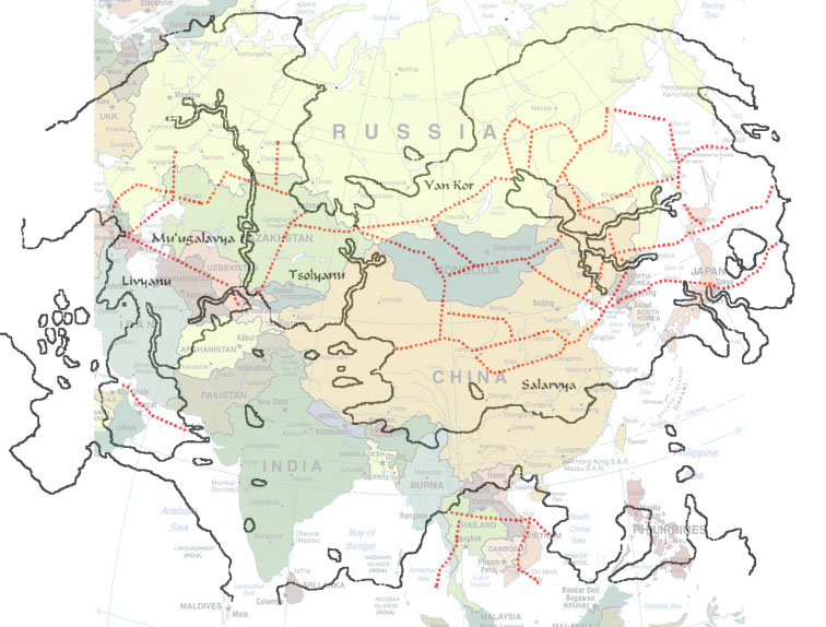
Comparison map between Tekumel's northern continent and Asia
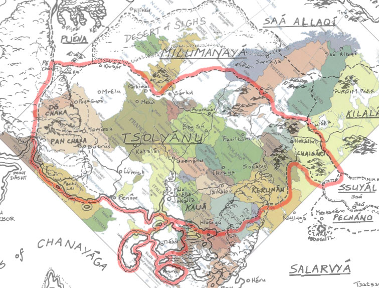
Comparison map between Tsolyanu and Europe

Cities

Tsolyanu

Tumissa in eastern Tsolyanu
Setnakh in southern Tsolyanu (description)
Fasiltum in eastern Tsolyanu
Thri'il in northern Tsolyanu
Bey Su in northern Tsolyanu
Hekellu
Another Hekellu map (and map key)
Usenanu article with map
Pala Jakalla article with map

Sa'a Allaqiyani

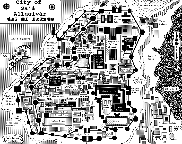
Sa'a Allaqiyor, the capitol

Kilalammu

Sirsum in eastern Kilalammu

Smaller Scale Maps

Sharu'una Fief article with map and gazeteer of Hekellu

Friday, January 4, 2013

Mapping the Office

So I was in a meeting today and I drew a map. My mapping hand is waaaay out of practice, so it's crude. It was first drawn with ball point pen, then felt-tip pen and highlighters. #fiveminutemap #fiveminutemapfriday